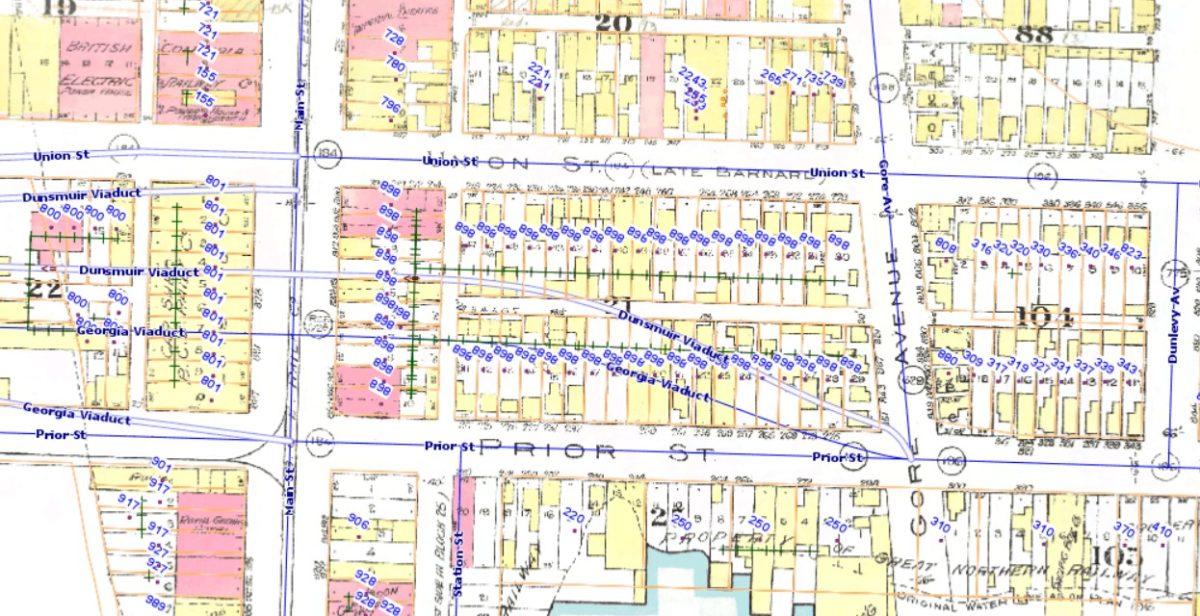
Pictured above is Vancouver’s 1912 Fire Insurance Map superimposed on the current streets and viaducts. The block bordered by Main, Union, Gore and Prior was demolished around 1970 to make room for the ramps for the Georgia and Dunsmiur viaducts. As shown, this block included 37 residential properties (along Union and Prior) and 10 commercial properties (along Main). The destruction of this block can be considered in the context of the very end of Vancouver’s 20 year “slum clearance” and “urban renewal” programs, which have been described in a previous post, that also obliterated many other blocks in Strathcona, including the block across the street on the northeast corner of Union and Gore. Under the program, which affected thousands of local residents, owners were offered a fixed price for their homes, in the range of $6,000 to $8,000, and houses were expropriated if an owner refused to sell.
The term Hogan’s Alley is sometimes used to refer to this block, although the term has not always been used consistently. John Atkins notes that Hogan’s Alley ran “from Gore to Main” [Strathcona – Vancouver’s First Neighbourhood]. Other authors have suggested it ran through to Jackson. For example Purvey and Belshaw [Vancouver Noir] describe it as “extending about two blocks to Jackson.” Wayde Compton [After Canaan] notes that the viaducts destroyed Hogan’s Alley, also suggesting it ended at Gore, and states that the building at 823 Jackson Avenue, which is two blocks away, “flanked Hogan’s Alley”. Several interviewees in Marlatt and Itter [Opening Doors] discuss Hogan’s Alley as the general area without a precise definition and in particular Austin Philips says it “ended around Jackson Avenue – that’s when you were out of Hogan’s Alley.” Canada Post, in the notes accompanying an envelope depicting the building at 823 Jackson Avenue asserts that Hogan’s Alley was a “four block-long dirt lane” without citing a source; then they quote Dorothy Nealy from Opening Doors but she doesn’t define Hogan’s Alley in that interview, and even extending to Jackson would only be three blocks.
Thus it’s hard to know how the term was used at the time. It seems likely that Hogan’s Alley was mainly associated with the T-shaped lane in the block that was destroyed . The north-south portion of this lane, which extends from the block to the south through to the block to the north was referred to historically as “Park Lane“. As noted in previous posts, the term Hogan’s Alley likely originated as a reference to a fictional place from the The Yellow Kid comics by R. F. Outcault.